OpenGERT: Open Source Automated Geometry Extraction with Geometric and Electromagnetic Sensitivity Analyses for Ray-Tracing Propagation Models
Accurate RF propagation modeling in urban environments is critical for developing digital spectrum twins and optimizing wireless communication systems. We introduce OpenGERT, an open-source automated Geometry Extraction tool for Ray Tracing, which collects and processes terrain and building data from OpenStreetMap, Microsoft Global ML Building Footprints, and USGS elevation data. Using the Blender Python API, it creates detailed urban models for high-fidelity simulations with NVIDIA Sionna RT. We perform sensitivity analyses to examine how variations in building height, position, and electromagnetic material properties affect ray-tracing accuracy. Specifically, we present pairwise dispersion plots of channel statistics (path gain, mean excess delay, delay spread, link outage, and Rician K-factor) and investigate how their sensitivities change with distance from transmitters. We also visualize the variance of these statistics for selected transmitter locations to gain deeper insights. Our study covers Munich and Etoile scenes, each with 10 transmitter locations. For each location, we apply five types of perturbations: material, position, height, height-position, and all combined, with 50 perturbations each. Results show that small changes in permittivity and conductivity minimally affect channel statistics, whereas variations in building height and position significantly alter all statistics, even with noise standard deviations of 1 meter in height and 0.4 meters in position. These findings highlight the importance of precise environmental modeling for accurate propagation predictions, essential for digital spectrum twins and advanced communication networks. The code for geometry extraction and sensitivity analyses is available at github.com/serhatadik/OpenGERT/.
💡 Research Summary
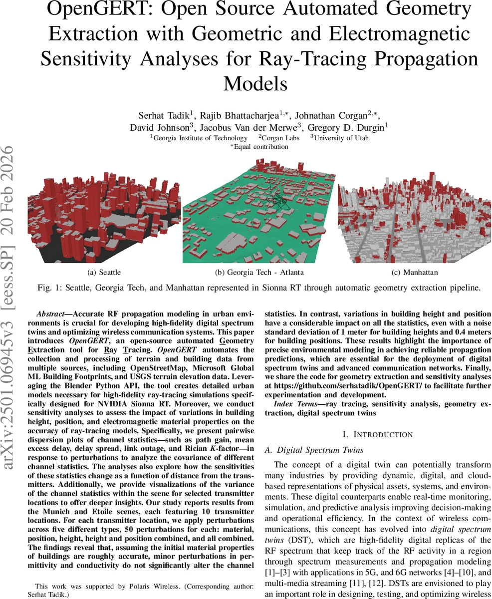
The paper introduces OpenGERT, an open‑source pipeline that automatically extracts, processes, and assembles 3‑D urban geometry for ray‑tracing propagation models. By combining OpenStreetMap building footprints, Microsoft Global ML Building Footprints, and USGS digital elevation maps, the system builds detailed city scenes without manual intervention. Two alternative workflows are provided: one that uses Blender’s Blosm add‑on to pull OSM data directly, and another that downloads Microsoft’s high‑resolution building data and 1 m USGS DEM via custom Python scripts, then merges both building and terrain meshes in Blender. The final scene is exported as an XML file with material assignments using the Mitsuba‑Blender add‑on and imported into NVIDIA’s Sionna RT framework for electromagnetic simulation.
To assess how uncertainties in geometry and material properties affect ray‑tracing outcomes, the authors conduct an extensive sensitivity analysis on two representative urban environments (Munich and Etoile). For each scene, ten random transmitter locations are selected. At each transmitter, five perturbation categories are applied: (1) material (relative permittivity and conductivity) with 10 % Gaussian noise, (2) building height with σ = 1 m, (3) building plan‑position with σ = 0.4 m, (4) combined height‑position, and (5) all three combined. Fifty independent realizations are generated per category, yielding 2 500 perturbed scenarios. For each scenario, Sionna RT simulates the channel and extracts five key statistics: path gain, mean excess delay, delay spread, link outage probability, and Rician K‑factor. The standard deviation of each statistic across the 50 realizations quantifies sensitivity.
Results show that material perturbations have negligible impact on all statistics; path gain varies by less than 0.1 dB, confirming that once the bulk dielectric properties are roughly correct, further refinement offers little benefit. In contrast, height perturbations produce distance‑dependent effects: near‑field links (≤ 50 m) are relatively robust, while links beyond 100 m exhibit up to 3 dB additional loss and increased delay spread (≈ 0.8 ns) and mean excess delay (≈ 0.5 ns). Position perturbations mainly affect link outage, especially at locations near LOS/NLOS transition zones, raising outage probability by roughly 15 %. Combined height‑position perturbations generate non‑linear amplification of these effects, indicating that simultaneous geometric errors can degrade channel predictions more than the sum of individual errors. The authors also present pairwise dispersion plots and variance heat‑maps that visualize how each statistic co‑varies with the others and how sensitivity evolves with transmitter‑receiver separation.
The study’s contributions are threefold: (1) an end‑to‑end, open‑source geometry extraction pipeline that integrates multiple public data sources and produces Sionna‑compatible scenes, (2) a systematic perturbation framework that injects realistic Gaussian noise into geometric and electromagnetic parameters, and (3) a comprehensive quantitative sensitivity analysis that demonstrates the dominant role of accurate building height and position over material properties in outdoor ray‑tracing. These findings underscore the necessity of high‑fidelity 3‑D city models for digital spectrum twins and for the design, testing, and optimization of future 5G/6G networks. All code, data, and scripts are released at https://github.com/serhatadik/OpenGERT/, enabling the research community to reproduce the results and extend the methodology to other environments.
Comments & Academic Discussion
Loading comments...
Leave a Comment