SuReNav: Superpixel Graph-based Constraint Relaxation for Navigation in Over-constrained Environments
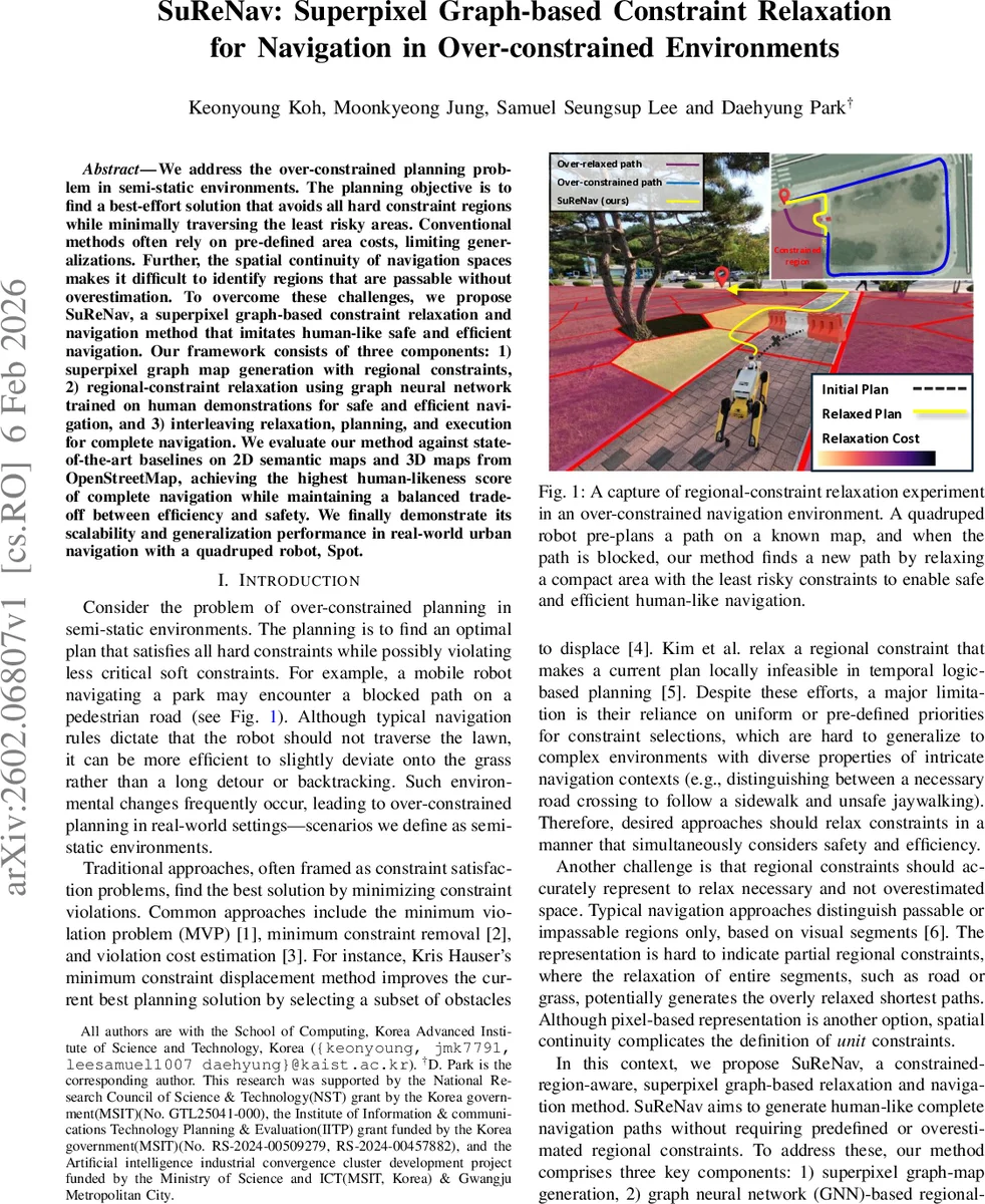
We address the over-constrained planning problem in semi-static environments. The planning objective is to find a best-effort solution that avoids all hard constraint regions while minimally traversing the least risky areas. Conventional methods often rely on pre-defined area costs, limiting generalizations. Further, the spatial continuity of navigation spaces makes it difficult to identify regions that are passable without overestimation. To overcome these challenges, we propose SuReNav, a superpixel graph-based constraint relaxation and navigation method that imitates human-like safe and efficient navigation. Our framework consists of three components: 1) superpixel graph map generation with regional constraints, 2) regional-constraint relaxation using graph neural network trained on human demonstrations for safe and efficient navigation, and 3) interleaving relaxation, planning, and execution for complete navigation. We evaluate our method against state-of-the-art baselines on 2D semantic maps and 3D maps from OpenStreetMap, achieving the highest human-likeness score of complete navigation while maintaining a balanced trade-off between efficiency and safety. We finally demonstrate its scalability and generalization performance in real-world urban navigation with a quadruped robot, Spot.
💡 Research Summary
**
The paper tackles the problem of “over‑constrained” navigation in semi‑static environments, where a robot must avoid all hard‑constraint regions while only minimally violating soft constraints. Conventional planners rely on hand‑crafted area costs or uniform priority schemes, which do not generalize well to complex, dynamic settings. SuReNav proposes a three‑stage framework that mimics human‑like safe and efficient navigation.
First, the environment map (2‑D semantic or projected 3‑D OSM data) is over‑segmented using the SLIC superpixel algorithm. Each superpixel becomes a node in a graph, preserving semantic homogeneity and sharp region boundaries. Node features consist of geometric centroids and semantic labels (including start/goal flags). Edges encode Euclidean distances between adjacent superpixels, yielding a compact, controllable‑granularity graph that can be updated online as new observations arrive.
Second, a graph neural network (GNN) estimates a “relaxation cost” for each node. The GNN follows the GraphGPS architecture: several GPS layers combine a message‑passing GatedGCN with a global Transformer‑style attention, allowing both local and long‑range context to influence the cost prediction. The output is a non‑negative scalar Ψ_G(r_i) for each node; free‑space nodes are masked to zero so that only soft‑constraint regions receive a penalty.
Third, the estimated costs are fed into a differentiable A* search (GraphMP). The planner maintains open/closed masks and accumulated costs g, and selects the next node via a softmax over (g + h) with temperature λ, making the whole search graph‑differentiable. During training, human demonstration trajectories are projected onto the superpixel graph, producing node sequences. The loss combines the path length term and the sum of relaxation costs, encouraging the planner to reproduce human‑like decisions about which soft regions to cross. Because the search is differentiable, gradients flow back to the GNN, enabling end‑to‑end learning from demonstration data.
After training, at runtime the system repeatedly (i) estimates node‑wise relaxation costs, (ii) runs the differentiable A* to obtain a feasible path that may include relaxed soft regions, and (iii) executes the path. If a hard obstacle blocks the current plan, the loop restarts, allowing dynamic re‑planning in semi‑static settings.
Experiments are conducted on three fronts: (1) synthetic 2‑D semantic maps with randomly blocked roads, (2) 3‑D maps derived from OpenStreetMap that include elevation and building geometry, and (3) real‑world trials on a Boston Dynamics Spot quadruped navigating a university campus. Baselines include Minimum Violation Planning, Minimum Constraint Removal, cost‑based A* planners, and end‑to‑end policy networks. Evaluation metrics are Human‑Likeness Score (edit distance to human trajectories), path length ratio, hard‑constraint violation count, and computation time. SuReNav achieves the highest Human‑Likeness (≈12 % improvement over the best baseline), zero hard‑constraint violations, and a 5–10 % reduction in path length while maintaining real‑time performance (<30 ms per planning step). The method is robust to variations in superpixel granularity (200–800 nodes) and GNN depth, indicating stable behavior.
Key contributions are: (i) formalizing a constrained‑region relaxation problem for semi‑static navigation, (ii) introducing a superpixel‑graph representation that captures spatial continuity and semantic consistency, (iii) a joint GNN‑A* learning framework that derives relaxation costs directly from human demonstrations, and (iv) extensive validation in simulation and on a real quadruped robot, demonstrating scalability and generalization.
Limitations include dependence on the quality of superpixel segmentation (over‑coarse regions may hide fine‑grained constraints), the need for sufficient human demonstration data for each new environment, and the current focus on 2‑D semantic layers (elevation or 3‑D structural constraints are only indirectly handled). Future work is suggested to integrate multi‑modal sensors (LiDAR, depth cameras), extend the graph to 3‑D volumetric supervoxels, and incorporate online reinforcement learning for continual adaptation in highly dynamic urban settings.
Comments & Academic Discussion
Loading comments...
Leave a Comment