Lightspeed Data Compute for the Space Era
While thousands of satellites photograph Earth every day, most of that data never makes it to the ground because downlink bandwidth simply cannot keep up. Processing data in the Low Earth Orbit (LEO) zone offers promising capabilities to overcome this limitation. We propose SpaceCoMP, a MapReduce-inspired processing model for LEO satellite mesh networks. Ground stations submit queries over an area of interest; satellites collect sensor data, process it cooperatively at light-speed using inter-satellite laser links, and return only the results. Our compute model leverages space physics to accelerate computations on LEO megaconstellations. Our distance-aware routing protocol exploits orbital geometry. In addition, our bipartite match scheduling strategy places map and reduce tasks within orbital regions while minimizing aggregation costs. We have simulated constellations of 1,000-10,000 satellites showcasing 61-79% improvement in map placement efficiency over baselines, 18-28% over greedy allocation, and 67-72% reduction in aggregation cost. SpaceCoMP demonstrates that the orbital mesh is not merely useful as a communication relay, as seen today, but can provide the foundations for faster data processing above the skies.
💡 Research Summary
The paper tackles the growing mismatch between the massive amount of Earth‑observation data generated by low‑Earth‑orbit (LEO) mega‑constellations and the limited downlink capacity of traditional radio‑frequency (RF) ground links. To avoid transmitting terabytes of raw imagery, the authors propose SpaceCoMP, a distributed processing framework that brings the MapReduce paradigm into the orbital mesh formed by inter‑satellite laser links (ISLs).
Core Concept
SpaceCoMP adds an explicit Collect phase to the classic Map‑Reduce workflow. A ground station submits a job that specifies an Area of Interest (AOI), sensor acquisition parameters, a map function, and a reduce function. The nearest visible satellite (the LOS node) acts as a coordinator: it identifies all satellites whose ground footprints intersect the AOI (Collectors), assigns nearby satellites as Mappers, and selects a single Reducer positioned to minimize the total distance from all Mappers. Collectors acquire raw sensor data locally, Mappers process the data over high‑bandwidth optical ISLs, and the Reducer aggregates intermediate results before sending the final, compact output back to the LOS node for RF downlink.
Technical Contributions
-
Distance‑aware Routing – The authors model the time‑varying geometry of LEO constellations (cross‑plane distance sinusoidally varies, polar seam events disable links, etc.). Their routing algorithm exploits this predictability to choose paths that keep hop count unchanged while reducing total physical transmission distance by 8‑21 % compared with naïve shortest‑hop routing.
-
Bipartite‑matching Scheduler – Mapping each Collector to a Mapper is cast as a maximum‑weight bipartite matching problem, where edge weights represent the expected ISL transmission cost (distance × data volume). Using the Hungarian algorithm, the scheduler achieves 61‑79 % higher placement efficiency than random allocation and 18‑28 % better than a greedy baseline.
-
Reducer Placement Strategy – By locating the Reducer near the geometric center of the AOI, the aggregation cost (total distance for all Mapper‑to‑Reducer transfers) drops by 67‑72 % relative to a naïve approach that routes each Mapper’s output directly to the LOS node.
-
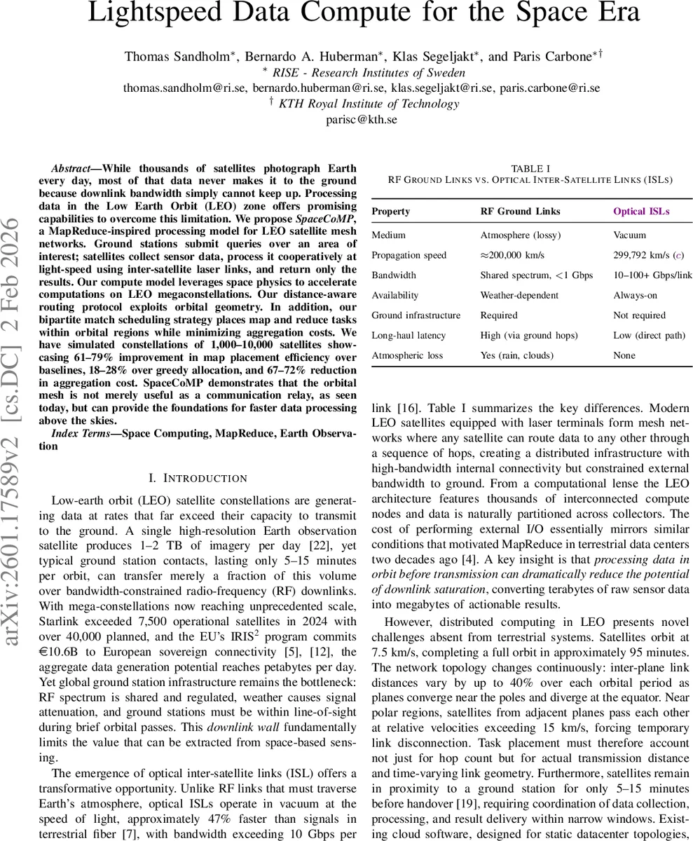
Simulation Framework – The authors evaluate SpaceCoMP on Walker‑Delta constellations ranging from 1,000 to 10,000 satellites, with ISL bandwidths of 10‑100 Gbps and vacuum propagation speed (≈ 299,792 km/s). Results confirm substantial gains in map placement efficiency, routing distance, and aggregation cost, translating into order‑of‑magnitude reductions in end‑to‑end processing time compared with a “collect‑then‑downlink” baseline.
Context and Related Work
The paper situates SpaceCoMP among three research streams: (i) distributed task scheduling in cloud data centers, (ii) the original MapReduce model, and (iii) wireless sensor/edge computing. It argues that existing cloud schedulers assume static topologies and binary locality, which are unsuitable for the continuously moving LEO mesh. Prior LEO edge projects (Krios, Celestial, SkyMemory) treat satellites as extensions of terrestrial infrastructure, whereas SpaceCoMP makes orbital dynamics a first‑class scheduling constraint.
Limitations and Future Directions
Current work does not address fault tolerance, dynamic re‑scheduling after satellite or link failures, or energy constraints of laser terminals. Real‑world ISL performance can be affected by pointing errors, occasional blockage during polar seam events, and power budgeting, which are left for future study. The authors suggest extending the framework with multi‑Reducer cooperation, reinforcement‑learning‑based cost prediction, and integration of on‑board storage management to handle larger workloads.
Impact
SpaceCoMP demonstrates that a LEO satellite constellation can serve not only as a high‑throughput communications backbone but also as a massive, distributed compute fabric. By moving computation close to where data is generated and by carefully exploiting the deterministic orbital geometry, the system dramatically reduces the amount of data that must traverse the scarce RF downlink. This opens the door to near‑real‑time analytics for global wildfire monitoring, disaster response, climate observation, and other data‑intensive Earth‑observation applications that were previously bottlenecked by downlink capacity.
Comments & Academic Discussion
Loading comments...
Leave a Comment