SkyLiTE: End-to-End Design of Low-Altitude UAV Networks for Providing LTE Connectivity
Un-manned aerial vehicle (UAVs) have the potential to change the landscape of wide-area wireless connectivity by bringing them to areas where connectivity was sparing or non-existent (e.g. rural areas) or has been compromised due to disasters. While Google’s Project Loon and Facebook’s Project Aquila are examples of high-altitude, long-endurance UAV-based connectivity efforts in this direction, the telecom operators (e.g. AT&T and Verizon) have been exploring low-altitude UAV-based LTE solutions for on-demand deployments. Understandably, these projects are in their early stages and face formidable challenges in their realization and deployment. The goal of this document is to expose the reader to both the challenges as well as the potential offered by these unconventional connectivity solutions. We aim to explore the end-to-end design of such UAV-based connectivity networks particularly in the context of low-altitude UAV networks providing LTE connectivity. Specifically, we aim to highlight the challenges that span across multiple layers (access, core network, and backhaul) in an inter-twined manner as well as the richness and complexity of the design space itself. To help interested readers navigate this complex design space towards a solution, we also articulate the overview of one such end-to-end design, namely SkyLiTE– a self-organizing network of low-altitude UAVs that provide optimized LTE connectivity in a desired region.
💡 Research Summary
The paper presents SkyLiTE, an end‑to‑end framework for deploying low‑altitude unmanned aerial vehicles (UAVs) as LTE base stations to provide on‑demand, wide‑area wireless connectivity. It begins by contrasting high‑altitude platforms (e.g., Google Loon, Facebook Aquila) with low‑altitude platforms (LAP) that operate from a few hundred meters to a few kilometers. The authors note that telecom operators such as AT&T and Verizon have already conducted trials using “Cell on Wings” (CoW) concepts, but that many technical challenges remain.
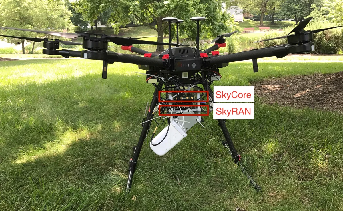
The proposed architecture envisions untethered rotary‑wing UAVs carrying an LTE eNodeB, antenna, backhaul radio, and a command‑and‑control (C&C) module. Two deployment modes are defined: (i) a stand‑alone mode where the UAV network provides local communications without Internet connectivity (useful for disaster response), and (ii) an Internet‑backhauled mode where the UAVs connect to a ground gateway or satellite to provide full Internet access. The system consists of three tightly coupled layers: the radio access network (RAN), the wireless multi‑hop backhaul, and the core network (Evolved Packet Core, EPC).
RAN challenges are explored in depth. First, the UAV must localize ground user equipment (UE) even when GPS is unavailable, requiring inference from LTE signal measurements (RSSI, timing, beam information). Second, an RF map that predicts path loss for every possible UAV position must be built on‑the‑fly; this demands efficient sampling of the operational airspace, accounting for antenna beam patterns, UAV orientation (yaw/tilt), and obstacles such as trees and buildings. Third, the UAV must solve a multi‑objective optimization to select its 3‑D position and antenna tilt that simultaneously maximizes coverage area, signal strength, and capacity for a heterogeneous set of users. Fourth, when multiple UAVs are deployed, a distributed self‑organization algorithm is needed because a centralized solution would be too slow and communication‑intensive. The algorithm must avoid UAV‑to‑UAV collisions, coordinate RAN coverage, and respect backhaul constraints, while also minimizing unnecessary handovers for static users.
Backhaul challenges focus on constructing a high‑capacity wireless mesh among UAVs. The authors discuss the choice of mmWave or free‑space optical (FSO) links, spectrum allocation, interference management, and dynamic routing. Because the backhaul is also wireless and multi‑hop, its reliability cannot be guaranteed for safety‑critical C&C; therefore, a separate, always‑available C&C path (macro‑cell towers or satellite) is recommended. The backhaul must also adapt to UAV mobility, energy constraints, and varying link quality, requiring robust SDN‑based control and fast re‑routing.
Core network challenges arise from moving the traditionally wired EPC onto a wireless mesh. The EPC functions (MME, SGW, PGW) must be lightweight, possibly virtualized at the edge, and able to tolerate higher latency and packet loss. The paper proposes an SDN‑controlled EPC that can be dynamically instantiated on UAVs or on ground edge servers, allowing the network topology to be reconfigured in real time as UAVs move or are added/removed.
The paper also contrasts fixed‑wing and rotary‑wing UAVs. Fixed‑wing platforms need continuous forward motion, making path planning and energy efficiency central to design, while rotary‑wing platforms can hover, offering finer granularity in coverage but suffering from limited battery life.
Through simulations and a small‑scale prototype, the authors demonstrate that SkyLiTE can achieve acceptable user throughput, rapid deployment, and graceful degradation when UAVs fail or the backhaul is partially disrupted. The work highlights that, despite regulatory and endurance constraints, low‑altitude UAV LTE networks are a viable solution for disaster recovery, temporary events, and underserved rural areas, provided that the intertwined challenges of localization, RF mapping, multi‑UAV coordination, wireless backhaul, and lightweight EPC are jointly addressed.
Comments & Academic Discussion
Loading comments...
Leave a Comment